South Korea: Cycling Seomjingan River Trail and Yeongsangang River Trail (313km)
Louise George

Sunset at Seomjingan River Trail Head
South Korea in late autumn: November. We had completed the 4 Rivers Trail (you can read about that ride here) and had five nights in Busan. We are not the best at following signage and we have read other blogs about linking these two river trails by riding many kilometres on a motorway, (that we would prefer not to do) so we imported a file from RidewithGPS to both Nev’s Komoot App and my Garmin so we wouldn’t go wrong, at least with navigational errors. We were relaxed about leaving Busan and getting to the Eastern bus station because we had already ridden from the suburb where the station is located, and confident that we knew where it was, and then pleased that our return ride to Sansong was straight forward. Navigation though, was clearly not the only aspect of touring we could get wrong! A bus to Gwangyang was already at the terminal. Nev went in to purchase a ticket for the 11:00 bus to give us time to unload the bags and get the bikes ready for stowage in the luggage compartment. Nev returned to where I was waiting, with tickets for the 11:19 bus. He commented that it seemed an unusual time and showed me that the time space on the ticket showed 10:10. We decided that must be the time of purchase. We prepared for travel and waited. Another bus parked in Bay 25, due to depart at 11:00. By this time Nev had wandered off to the toilet but he was taking such a long time I knew he was nosing around the outdoor clothing outlet stalls. While Nev was gone the driver of this second bus to Gwangyang asked to look at my ticket. He pointed to 10:10 and said “time!” “Change!” I realised that what Nev thought was the departure time was actually today’s date written in the format 11:19! We should have been on the 10:10 bus, although that would have been impossible, because it departed moments after we purchased the tickets. Nev had still not returned to me when that second bus departed. By now we had actually missed two buses! Nev easily got the ticket changed to 12:20 p.m. By the time that bus arrived we had been standing at the station, in the cool shade, for 2 hours, presiding over our pile of gear.
The two hours of bus travel to Gwangyang was luxurious, with plenty of leg room and a seat that could recline with leg support for those that enjoy that level of comfort. Because we had up to now been following rivers I thought the road route might offer different scenery, however apart from the absence of rivers it was much the same. Broad cultivated valleys punctuated by hill mounds covered in foliage that had gone beyond the autumn tones and now brazen, appeared to just need a strong breeze to float the remaining leaves to the ground.
Seomjingan River Trail
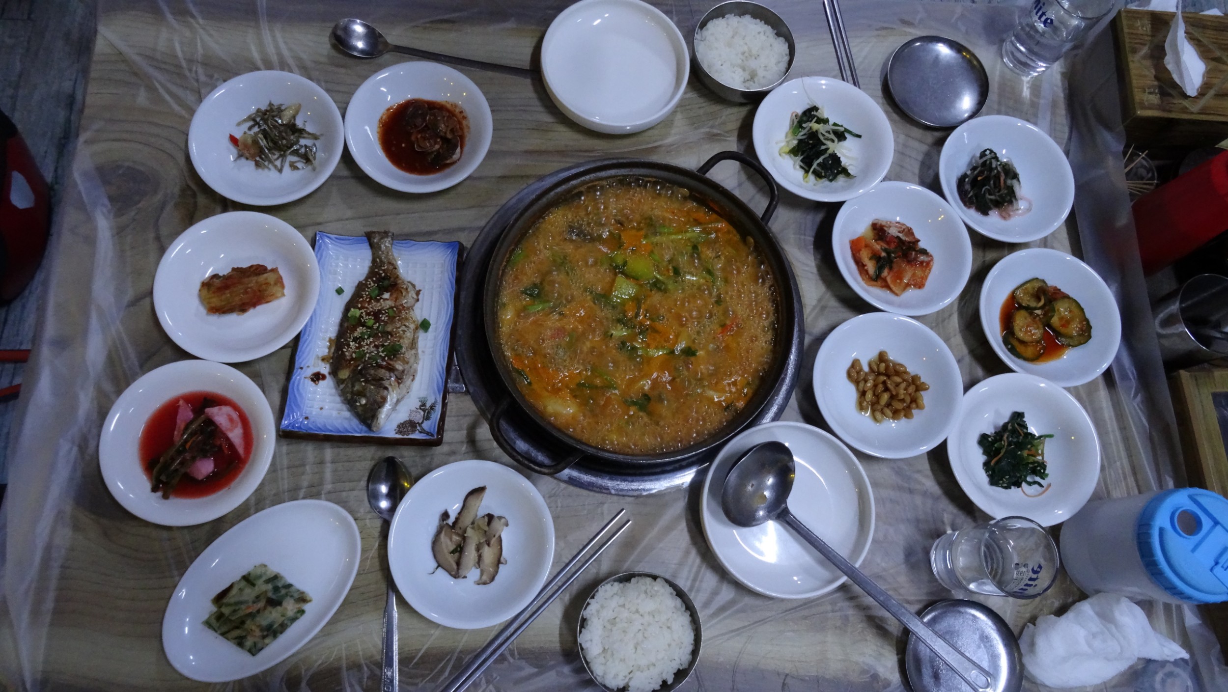
On the bikes we had 9 km to the trail starting point at the Seomjingang River mouth. We arrived at 3:30 and, as there was a camping area next to the trail-head, we decided to pitch our tent under a pergola to let it dry out thoroughly. I can’t say I’ve been excited about camping in South Korea and that has disappointed Nev, but it’s been very cold the two nights we had previously camped, and the nights are very long with darkness from 6:00pm to 7:00am. Also with no electricity or data , many hours of reading becomes the only entertainment. I agreed to camp rather than ride in the direction of Hadong, 20 km away, probably the nearest town with a Motel. The cold began to settle as soon as the sun dropped. Tonight rather than sit around in the cold we headed off to a restaurant we had located through Maps.me, that was 2 km away on the other side of the river. There were a number of ‘fish’ restaurants and we chose the one with the brightest neon lights. It was only 6pm and we were the only patrons. We had no idea what to order and the only thing we could establish with any certainty was that the fish had to be purchased by the kilo, that at equivalent to $72AU, was way out of our budget! A soup on the menu was reasonably priced so we pointed to that picture. The bubbling hot dish was placed centre-table with the gas flame lit beneath it, keeping the broth at a fast boil. The spicy stock was full of delicate tiny eel, beef bones and many vegetables. On the table, surrounding the soup tureen, a bowl of hot rice each was placed, along with twelve small dishes of cold food, and one small whole fish. We sat awkwardly on the floor at the low table and tucked into the feast. One of the women working in the restaurant came over from time to time and watched, with a huge grin and sparkling eyes (clearly Westerner clients are a rare source of amusement), to see how we were getting on. She wanted to chat but that was hopelessly funny, even using Google Translate. Later she kindly brought us a Persimmon, sliced for our dessert.


The night was as cold as I anticipated it would be. Our sleeping bags are summer weight and even with most of my clothes on, as well as my hat and scarf, the chill seemed to permeate my bones. At 7 am it was 2C.
Following our Meusli breakfast, the gear was packed quickly as the pergola overhead had kept everything dry. With the Seomjingan River as our guide, we set off. There wasn’t a breath of wind and as the day progressed we were able to strip off some layers of clothing. We’ve made a habit of stopping for coffee around the 20km point, but we were at 35km and still hadn’t come across a cafe or a shop selling food. We were beginning to wonder if we’d even get a lunch break when at 40km we came across a restaurant, about one kilometre before Nampo Bridge, with a few vans parked outside. We sat at the only table, along with some working men, and were served lunch. There was no menu; everyone was served the same: thick beef bone broth, rice and nine cold accompaniments, similar to last night’s meal. Men came and went as we ate the very hearty meal, with a lot of liquid for rehydration.
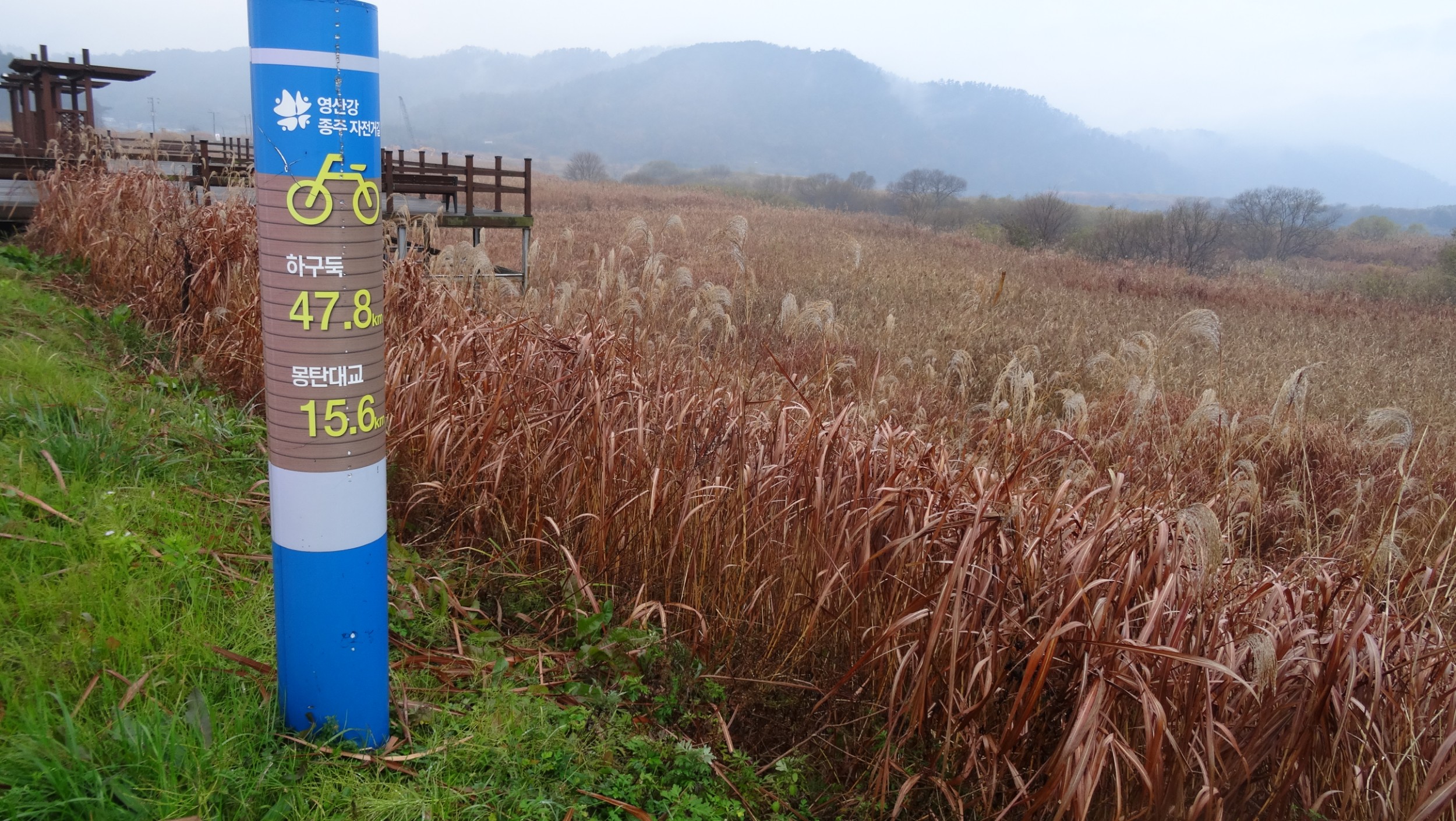
It would be almost impossible to take a wrong direction on this trail as the course is marked with a solid blue line painted the entire length. Signage to checkpoints is also very good, so when we watched some cyclists turn onto our route, (the only ones we had seen today), with that distraction we overlooked that Namdo Bridge was our Certificate Registration spot. Two kilometres further there was a coffee van so we stopped for a cappuccino, and Nev realised the error. We’d discussed not double-backing for check-points when we’d missed some on the last river trail we rode, so continued on. One of our difficulties is that we are unable to interpret the many signs that show points of interest, and I assume also accommodation options along the route. The Korean, Naver Navigation App, would have been useful, as it shows the trail and also place names in Korean and English but data is needed to use it, and we do not have a Korean CIM card as we had not purchased a Tourist CIM in Seoul. The Maps.me App, with South Korea downloaded, had helped us identify a town that had a Motel and we were happy to finish our day at Ace Motel in Yongjeong, having covered 70 kms.


We had a late start to the day as Nev had been vomiting in the night. At 10:00 o’clock the morning chill had not lifted however we set off in 4C and it remained at that temperature for much of the time we were riding. At least the air was calm and dry. Nev had little energy and we decided to make the day a shorter distance, slowly covering a very pretty, but cold 46.2km. Just after the Hyanga Park checkpoint Tunnel we diverted 5km away from the course to find a Motel in Sunchang where Nev went to bed for the rest of the day.


Next day dawned with weak sunshine and with Nev feeling better, we set off without panniers. We had identified that the return route, linking Seomjingan and Yeongsangang Rivers, came to within a few kilometres on the other side of Sunchang city. It seemed sensible to have a shorter day’s ride, with light bikes, and have two nights at Goldeun Motel.
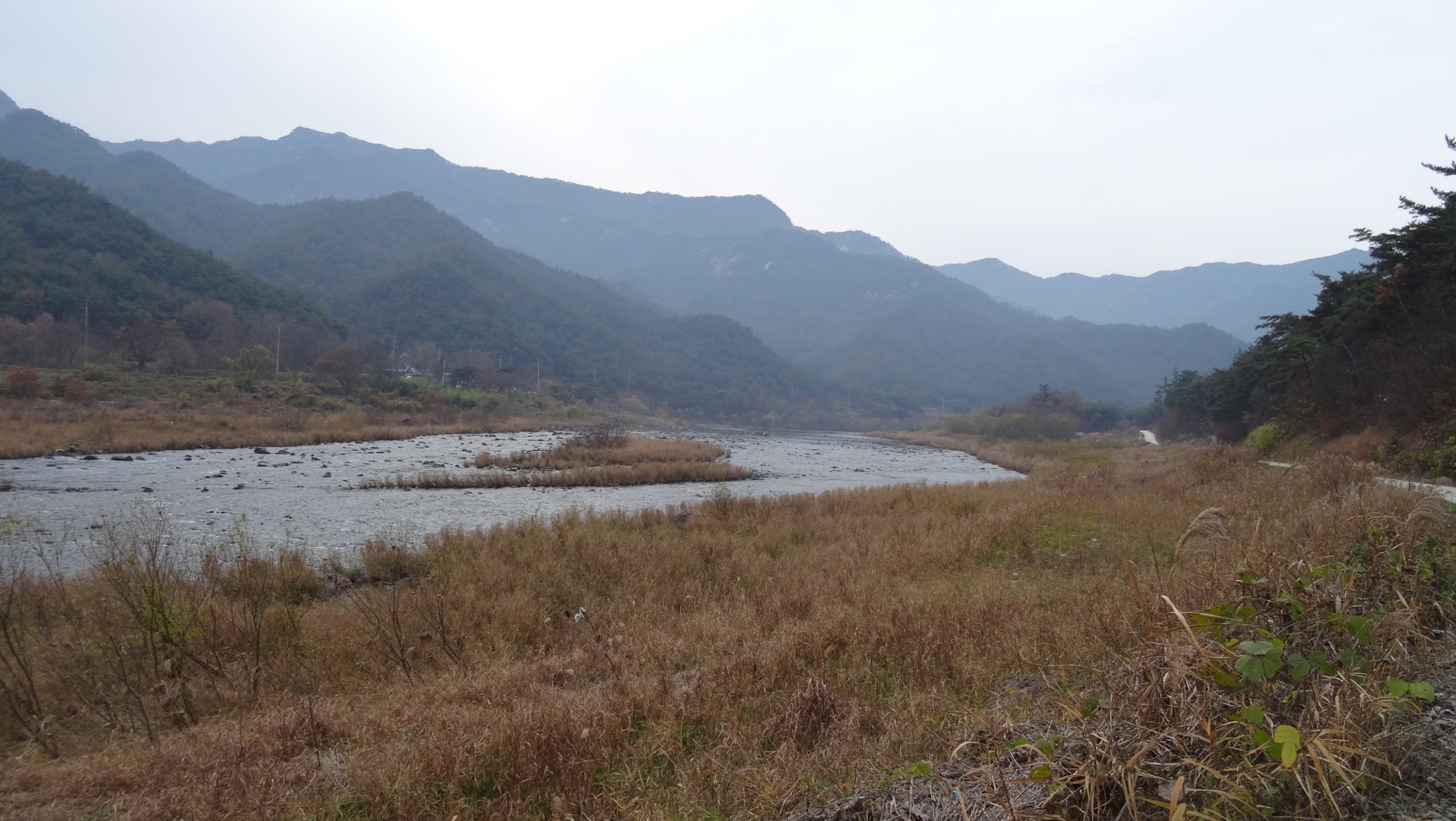
The trail continued beside the river that flowed and snaked through deep valleys. With less flat fertile areas the fields of rice and onions were much smaller. Occasionally a bright crop of red chillies added colour. At Janggunmok there was an area of wooden platforms for campers. Across the river were some cabins and later we passed glamping tents. This appeared to be an area popular for summer river activities, and hiking trails, but at this time nothing was open. At Seomjinggangdam, the final Certificate Registration on this river trail, we were delighted to see a Coffee sign, the first in 40km. Coffee with cake, served in a tiny cafe, where the heating was so intense that I stripped down to my first layer, was our chosen celebration on finishing Seomjingan River Trail. Back on the bikes we doubled back 5 km then took a more direct road route to Sunchang. What a difference a little sunshine makes. We were wearing just as many clothes as yesterday but the sun-bright high of 8C reached us around midday and with a few climbs we were soon stripping off some layers. We had just clocked 60 km on arriving back at our accommodation.


Yeosangang River Trail
Tyres crunched the frost as they crossed the bridge but the sun held promise of warmth. The route not far from Sunchang-eup led us to a flight of concrete steps. At this point I was thinking ‘oh, here we go, this is the motorway that I’ve read about, and the course has brought us to it at this stepped side entrance point so we can’t see any ‘bicycles not allowed’ signs’. The bikes were unloaded, gear lugged up to the highway and then the bikes carried up in turn. Actually for six kilometres we rode on a dual carriageway, that had light traffic and a wide shoulder, so there was no difficulty. We left the highway and took a secondary road up to Damyangdam, our starting point for Yeongsangang bicycle path.


The first section of trail was on a rubberised surface similar to the protection under children’s play equipment at parks. The surface felt like it was gripping the tyres and slowing us down. Fortunately a stop-bank with a gravel path on top, travelled in the same direction so for a while we took that option.
We found Yeosangang River Trail very easy to follow. The solid blue painted line continued, but with the bonus of directional signage being in both Korean and English. There were also two different types of signs, marking each kilometre. The trail lead us through Gaeksa-ri, a pretty tourist orientated town with many coffee shops, restaurants and a bamboo park. Our travel continued in the same vein as other river trails. The route was usually along the stop-bank that gave us views of the river on one side and acres of greenhouses shining as their coating of taut plastic glistened in the sun on the other. Occasionally there was a rice field or garlic crop that was planted in neat rows with their tops poked up through circles punched in plastic. The river had many bridge crossings, but we stayed on the left bank with the trail usually dropping beneath a bridge, so the path was continuous, punctuated with 7% descents to get below a bridge and then a 7% ascent to rise back to the path.


The river had trickled from the dam, but flow increased as tributaries entered. Occasionally a weir would reduce the flow to pools surrounded by grasses, habitats for birds, then later the river would broaden again.
By Gwangju the river was very wide with the banks linked by many bridges. The city extended about 12km each side, beyond the river, with high-rise apartments jostling for river views. We wanted to split the trail into two days riding, so continued to a motel on the outskirts of Haksan-ri. Our odometer recorded 70 km for the day. As there were no shops nearby, we heated our packets of noodle meals and ate in the room.

Gwangju River Side
There was the occasional spit of rain as we put our panniers on the bikes but by the time we’d ridden the 3km to seek out breakfast it was raining heavily. We drank our coffee at a cafe, then from the 7/11 brought food: hard-boiled eggs, tuna rice cakes and sandwiches, that we ate at the first pergola we came across, beside the river path. Our course continued along the stop-banks with a couple of very steep, but fortunately short, climbs adding riding challenge but little in the way of interest as our view was totally obscured by the rain and fog.

Fortunately the rain stopped later and we eventually dried out except for the pools in our shoes. I was hoping to knock-off the 67km today without a break but with only 20km to go, energy levels were low. We left the river path but continued riding parallel to our course, hoping to find a shop. We found ourselves riding through a rural setting of acres of rice paddies, that appeared to sprout green shoots before our eyes, as they soaked up the rainwater. Occasionally there was a cluster of implement sheds and houses, but no shops. Back at the river we stopped at a shelter and ate the last of our food supplies. Three slices of dry bread, that was three days old and had a slight coconut flavour, spread with crunchy peanut butter and topped with cherry tomatoes, one Persimmon, a handful of walnuts. Our ride into Makpo continued along the stop-bank of what was now a very broad river. We were joined by a cyclist from Newcastle, UK who had been working at Makpo for a few months in the shipping industry. He was delighted to have English speakers to converse with. Later when we stopped at the final Certification Registration kiosk, a Korean man, out walking with his family on the trail, stopped me for a chat. Later, when we stopped at a cafe, the man sitting at the table next to us happened to be a teacher of English and he struck up a conversation. We hadn’t spoken to anyone for over a week so this was a wonderful way to end our last day on mainland Korea. By the time we checked into a Motel near the port we had completed 80km. Tomorrow we take a ferry to Jeju Island. You can read about our circumnavigation of Jeju Island, following the Fantasy Bicycle Trail here.